On Upper Broadway ...

First of all, I want to apologize for the lateness of this post. I intended it to be done in April. (Yes, April, that's when I started writing this!) This time the main hold-up is me fighting with Blogger's "New Improved" editor! It's quite the learning curve, even for someone like me who regularly has to adapt to new software and methods. It strips out the comments I use for place-holding and such and the generated layout is often times far from what I expect. :(
But anyway ...

Today we're going to explore a small section of Council Bluffs' Great White Way, Broadway, specifically the area sometimes known as "Upper Broadway", that which is just northeast of the core of the downtown Council Bluffs central business district.

Despite the Great Recession, parts of the area are most definitely "on the way up" and thriving! This area includes a showcase aimed at both visitors and local residents.

Yes, there's some historical significance here too ...

This portion of Broadway was part of the original (first generation) Lincoln Highway, which ran from Weehawken, New Jersey (there was a ferry to Manhattan, but this is where the paved road began) westward to San Francisco.
The name Broadway goes back many centuries in many cultures, decending from, among others, Old English
Bradewie and Dutch
Breede weg. It means, as the name implies, a broad path or street. Despite its commonality in America, it's not one of the more common street names. "Tree" and "President" street names hold that honor.
In Council Bluffs, as in Manhattan, Broadway is not a street, but an avenue, as both examples (mostly) parallel avenues and intersect streets. In fact, at least to my ear, the term "Broadway Street", as used in Kansas City and Chicago, sounds awkward. It just doesn't sound right! :)
Council Bluffs, as does Manhattan, has multiple thoroughfares named Broadway. The most familiar is West Broadway which begins at 1st. Street and runs southwest and west almost to the Missouri River. East Broadway heads northeast from 1st. St. to the confluence with Kanesville Boulevard, and North Broadway runs north from that juncture, following the route of the Old Lincoln Highway, to the city line.
The area we'll be exploring is bounded roughly by the intersection of Broadway and Main. Street on the southwest, venturing northeast to the vicinity of Broadway and Frank Street. The area is shaded below.

Of special interest is the "100 Block", shaded slightly darker, which is a very prominent revitalized area, listed on the National Register of Historic Place.
We'll start our venture at Main Street, working northeast ...
Most of the buildings along this stretch are in very good condition, with most of them currently occupied by apparently-thriving businesses.

However, unfortunately, this district, as with many others I've explored with you, has its share of vacant buildings, and the first block we come upon, the 400 block, is no exception.

As we round the curve at Fourth Street, we come upon a (yawn!) nondescript strip mall to the southeast and the (former) Midlands Mall to the northwest.

You'll notice that two prominent churches will be appearing in several of the photos. The one above is St. Peter's Roman Catholic Church, located a block behind us roughly where Pierce Street and Bluff Street collide. (Notice the airliner on its approach to Eppley.)

Back in my days in Council Bluffs (yes, I'm a once-resident of Kanesville), Upper Broadway was anchored by the Midlands Mall. This was a thriving urban mall in the 1970s, hosting shops, entertainment, and food/drink/nightlife.

In the 1980s, Mall Of The Bluffs opened on the east side of Council Bluffs and **POOF** all of the business migrated.
(For some reason, this "new improved" editor will not let me use angle brackets for emphasis, no matter what I do!) :(
As with The Center and Southroads, Midlands Mall is now mostly offices.

Although I really hate to see any business fail, there's some poetic justice in watching Mall Of The Bluffs join the Dead Mall Club! {sly grin} :)
The Omni Theater, once part of the Midlands Mall complex, still clings to life.

Opposite the once-mall on Second Street begins the heart of the revitalized area.

Including a recently-revamped thrift shop and food pantry, just 'round the corner from the action.

(Dammit! Why did those idiots who aspire to be morons who wrote this thing insist on removing html comments!)
As part of the recent Streetscape Project, various brick structures, among other improvements, have been erected.

This particular pylon commemorates the long-lived Fairmount Park.

This one commemorates, well, 2nd. Street. :)

This one the Ogden Hotel, once on this site (see below) ...

... and this one, well, uh ... perhaps the lobby of the Ogden?

The Streetscape Project, which began in 2008, was jointly-funded by several public and private concerns.

As we venture northeast, we come upon the 100 Block, the very popular revitalized area of Upper Broadway.

This is the block bounded by, well, First and Second streets.

Several popular bars and restaurants, among other businesses, have recently emerged along this block!

The 100 Block is now designated an "Entertainment District", allowing for outdoor dining and relaxed regulations concerning open adult beverages.
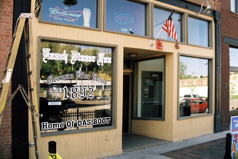
The crown jewel of Block 100 was, for the late 19th. and most of the 20th. Century, the Ogden House Hotel.

Two incarnations of the Ogden Hotel, host to Presidents, celebrities, and dignitaries, stood on the northeast corner of Broadway and Park Avenue until the late 1970s.

Notice the Hughes Motors Chevrolet signs on the adjacent building, still standing.

The Hughes-Irons Building is currently home to Dixie Quicks, a recent transplant from downtown Omaha.

Ok, I admit that I first thought the name was an attempt on a pun of Dixie Chicks. They tell me (the ubiquitous "they") that a "quick" is a meal, somewhat related to that served by the southern "meat and three" diners. I looked it up. I can't find it in any dictionary. I googled it. Nope! Urban Dictionary? Not in there either, but there are a few rather amusing definitions. :)

Dixie Quicks is extremely popular, especially after it was featured on
Diners, Drive-Ins, and Dives, and more so since moving from Omaha. It's difficult to get a table or even a reservation, particularly if your name happens to be Lydia. The food is very good, in my memory, anyway, I have yet to dine there since they moved from Omaha.
Dixie Quicks shares the building with the RNG gallery. You can now peruse the artwork as you wait for your table. :)

Until recent decades, the building housed an auto dealership.

Also sharing the building with Dixie Quicks and RNG is the Council Bluffs Chamber of Commerce and allied agencies.

Apartments (Hughes-Irons Flats) are available on the upper level as well.

On the north (northwest) side of Upper Broadway are several bars, such as Glory Days and Barley's ...

... both featuring outdoor seating ...

... and some which are inside only ...


(Go Big Red! Go Hawkeyes! Yes, that season will be coming around soon!)

Not just cupcakes, but wood-fired free-range cupcakes! (That has to be about as trendy as you can get!) :)

... a law office ...

... an engineering firm ...

... and a local music dealer.

I won't attempt to use any $5 hoity-toity words to describe it this time. :)

Wow, quite an assortment! We also have a flower shop ...

... a couple salons ...


... a shoe shop ...

... bicycles ...

... optical shop ...

... and last but not least ...

... a business which really sucks! :)

And ... coming Real Soon ...

Wow, all of that culture in one block! :) It's absolutely overwhelming. :) :)
Some of the southeast side of the 100 Block is still a bit underwhelming, for now that is.

Anchoring the corner of Broadway and First Street is Broadway (United) Methodist Church, the unquestionable landmark of Upper Broadway!


Like A Rainbow ... :)

Crucifix garden!

Speaking of overwhelming, such is the contrast of the two blocks divided by First Street!

This strip, just northeast of First, has definite potential, but as we wander further from First, it's obvious that we've ventured out of the area dans le vent!

We're now officially on East Broadway. We do have a few structures which have been spiffed up, such as this jewelry shop and chiropractic office ...

... and the renovated foursquare below.

However, creeping ubiquity ...

... and shades of Common Cloth abound.

Including, of course, the recent oh-so-common franchise of the great 21st. Century institution, For Lease. :(

One shining star, a few blocks away from the real action, is a great locally-owned independent pizza shop!

One particular part of Upper Broadway has realized its potential, and there are other adjoining parts which have potential which needs to be realized.
We'll continue to explore parts of Old Kanesville ... :)